
- Afhalen na 1 uur in een winkel met voorraad
- Gratis thuislevering in België vanaf € 30
- Ruim aanbod met 7 miljoen producten
- Afhalen na 1 uur in een winkel met voorraad
- Gratis thuislevering in België vanaf € 30
- Ruim aanbod met 7 miljoen producten


Omschrijving
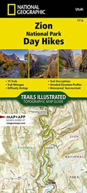
- Waterproof - Tear-Resistant - Topographic Map
Zion was officially established as a national park in 1919. One of only two scenic rivers in Utah runs through the park, and over 84% of the park's land is designated as wilderness. Visitors can experience a variety of activities in the park from front-country camping and biking on roadways, to wilderness hiking, backpacking, canyoneering, river trips, and stargazing. The park ranges in elevation from 3,666 to 8,726 feet and supports a wide assortment of plants and animal life like ponderosa pines and desert reptiles.
The Zion National Park Day Hikes Topographic Map Guide contains detailed maps for 15 of Zion's finest day hikes. It includes well-known hikes and some off-the-beaten-path trails. They range from easy strolls to strenuous climbs, selected to give you a sampling of all the park has to offer. Together, they cover almost 100 miles of adventures. One-third of the selected hikes are less than 4 miles long, two-thirds are less than 7 miles, and two hikes are longer than 11 miles long.
Each of the 15 maps include directions to the trailhead, the total distance to complete the hike, and an estimate of the degree of difficulty. Also provided are elevations of key points on the trail, an elevation profile for the hike, and a calculation of the hike's total elevation gain. Concise trail descriptions will help you find the hikes that best suit your interests, conditioning, and available time.
Every Trails Illustrated map is printed on "Backcountry Tough" waterproof, tear-resistant paper. A full UTM grid is printed on the map to aid with GPS navigation. Every map purchase helps support the National Geographic Society, an impact driven, nonprofit organization with global reach that uses the power of science, exploration, education, and storytelling to illuminate and protect the wonder of our world.
- Map Scale = 1:31,680
- Folded Size = 4.25" x 9.38"
Specificaties
Betrokkenen
- Auteur(s):
- Uitgeverij:
Inhoud
- Aantal bladzijden:
- 44
- Taal:
- Engels
- Reeks:
- Reeksnummer:
- nr. 1712
Eigenschappen
- Productcode (EAN):
- 9781566959087
- Verschijningsdatum:
- 31/05/2023
- Afmetingen:
- 104 mm x 239 mm
- Gewicht:
- 58 g


Alleen bij Standaard Boekhandel
+ 41 punten op je klantenkaart van Standaard Boekhandel
E-BOOK ACTIE


Beoordelingen
We publiceren alleen reviews die voldoen aan de voorwaarden voor reviews. Bekijk onze voorwaarden voor reviews.