
- Afhalen na 1 uur in een winkel met voorraad
- Gratis thuislevering in België vanaf € 30
- Ruim aanbod met 7 miljoen producten
- Afhalen na 1 uur in een winkel met voorraad
- Gratis thuislevering in België vanaf € 30
- Ruim aanbod met 7 miljoen producten


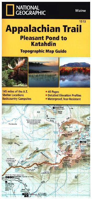
Appalachian Trail: Pleasant Pond to Katahdin Map [Maine]
Trails Illustrated
Engels
€ 15,95
+ 31 punten
Omschrijving
- Waterproof - Tear-Resistant - Topographic Map
The Pleasant Pond to Katahdin Topographic Map Guide makes a perfect traveling companion when traversing the northern Maine section of the Appalachian Trail (A.T.). The A.T. through Maine offers some of the most challenging sections of trail along the A.T., both in rugged terrain and weather conditions, and is not recommended for the unprepared hiker. Katahdin in Baxter State Park marks the A.T.'s northern terminus and for many hikers it also marks the end of a months long journey.
Each A.T. Topographic Map Guide includes detailed topographic maps at a detail of 1 inch = 1 mile. Each page is centered on the A.T. and overlaps with the adjacent pages so there is little chance of getting lost. Along the bottom of each page is a trail profile that shows the distance between shelters, camping areas, and trail access points. The map and trail profile provide a step by step visual guide to hiking the trail, mile by rugged mile. The Topographic Map Guide is built for all levels of hiking enthusiasts, from the day tripper to the multi month 'thru-hiker'. The front pages of the printed Topographic Map Guide include resupply information, town inset maps, camping options, and much more.
Every Topographic Map Guide is printed on "Backcountry Tough" waterproof, tear-resistant paper. A full UTM grid is printed on the map to aid with GPS navigation.
Other features found on this map include: Bald Mountain Brook Shelter, Barren Mountain, Baxter State Park, Carl A. Newhall Shelter, Chairback Gap Shelter, Chairback Mountain, Cloud Pond Shelter, Cooper Brook Falls Shelter, East Branch Shelter, Greenville, Horseshoe Canyon Shelter, Hurd Brook Shelter, Katahdin, Katahdin Stream and The Birches Shelter, Leeman Brook Shelter, Logan Brook Shelter, Long Pond Stream Shelter, Monson, Moxie Bald Shelter, Pleasant Pond Shelter, Potaywadjo Spring Shelter, Rainbow Stream Shelter, Wadleigh Stream Shelter, White Cap Mountain, Wilson Valley Shelter.
- Map Scale = 1:63,360
- Folded Size = 4.25" x 9.25"
Specificaties
Betrokkenen
- Auteur(s):
- Uitgeverij:
Inhoud
- Aantal bladzijden:
- 40
- Taal:
- Engels
- Reeks:
- Reeksnummer:
- nr. 1513
Eigenschappen
- Productcode (EAN):
- 9781597756501
- Verschijningsdatum:
- 1/01/2022
- Formaat:
- Gelamineerd
- Afmetingen:
- 104 mm x 236 mm
- Gewicht:
- 113 g


Alleen bij Standaard Boekhandel
+ 31 punten op je klantenkaart van Standaard Boekhandel
E-BOOK ACTIE


Beoordelingen
We publiceren alleen reviews die voldoen aan de voorwaarden voor reviews. Bekijk onze voorwaarden voor reviews.