
- Afhalen na 1 uur in een winkel met voorraad
- Gratis thuislevering in België vanaf € 30
- Ruim aanbod met 7 miljoen producten
- Afhalen na 1 uur in een winkel met voorraad
- Gratis thuislevering in België vanaf € 30
- Ruim aanbod met 7 miljoen producten


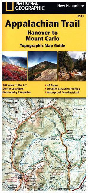
Appalachian Trail: Hanover to Mount Carlo Map [New Hampshire]
Trails Illustrated
Engels
€ 15,95
+ 31 punten
Omschrijving
- Waterproof - Tear-Resistant - Topographic Map
The Hanover to Mount Carlo Topographic Map Guide makes a perfect traveling companion when traversing the New Hampshire section of the Appalachian Trail (A.T.). The A.T. through New Hampshire is considered one of the more challenging sections of the trail, with long stretches above tree line and the possibility for rapid temperature change and snow any month of the year. But despite its difficulty, the trail offers some of the most spectacular scenery in New England as it leaves the Connecticut River valley to traverse the beautifully rugged White Mountains, a highlight of the A.T.
Each A.T. Topographic Map Guide includes detailed topographic maps at a detail of 1 inch = 1 mile. Each page is centered on the A.T. and overlaps with the adjacent pages so there is little chance of getting lost. Along the bottom of each page is a trail profile that shows the distance between shelters, camping areas, and trail access points. The map and trail profile provide a step by step visual guide to hiking the trail, mile by rugged mile. The Topographic Map Guide is built for all levels of hiking enthusiasts, from the day tripper to the multi month 'thru-hiker'. The front pages of the printed Topographic Map Guide include resupply information, town inset maps, camping options, and much more.
Every Topographic Map Guide is printed on "Backcountry Tough" waterproof, tear-resistant paper. A full UTM grid is printed on the map to aid with GPS navigation.
Other features found on this map include: Beaver Brook Shelter, Berlin, Carlo Col Shelter, Carter Dome, Carter Notch Shelter, Connecticut River, Crawford Notch State Park, Eliza Brook Shelter, Ethan Pond Shelter, Fire Warden's Cabin Shelter, Franconia Notch State Park, Full Goose Shelter, Galehead Shelter, Garfield Ridge Shelter, Gentian Pond Shelter, Gorham, Greenleaf Shelter, Guyot Shelter, Hanover, Hexacuba Shelter, Imp Shelter, Jeffers Brook Shelter, Kinsman Pond Shelter, Lakes of the Clouds Shelter, Lebanon, Lonesome Lake Shelter, Ludlow, Lyme, Madison Spring Shelter, Mahoosuc Arm, Mizpah Spring Shelter, Moose Mountain Shelter, Mount Carlo, Mount Cube, Mount Lafayette, Mount Madison, Mount Moosilauke, Mount Moriah, Mount Washington, North Woodstock, Norwich, Pinkham Notch, Rattle River Shelter, Smarts Mtn, Speck Pond Shelter, Trapper John Shelter, Velvet Rocks Shelter, White Mountain National Forest, White River Junction, Zealand Falls Shelter .
- Map Scale = 1:63,360
- Folded Size = 4.25" x 9.25"
Specificaties
Betrokkenen
- Auteur(s):
- Uitgeverij:
Inhoud
- Aantal bladzijden:
- 44
- Taal:
- Engels
- Reeks:
- Reeksnummer:
- nr. 1511
Eigenschappen
- Productcode (EAN):
- 9781597756488
- Verschijningsdatum:
- 1/01/2022
- Formaat:
- Gelamineerd
- Afmetingen:
- 107 mm x 234 mm
- Gewicht:
- 113 g


Alleen bij Standaard Boekhandel
+ 31 punten op je klantenkaart van Standaard Boekhandel
E-BOOK ACTIE


Beoordelingen
We publiceren alleen reviews die voldoen aan de voorwaarden voor reviews. Bekijk onze voorwaarden voor reviews.