
- Afhalen na 1 uur in een winkel met voorraad
- Gratis thuislevering in België vanaf € 30
- Ruim aanbod met 7 miljoen producten
- Afhalen na 1 uur in een winkel met voorraad
- Gratis thuislevering in België vanaf € 30
- Ruim aanbod met 7 miljoen producten


Omschrijving
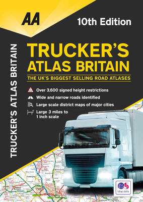
Perfect for professional drivers to easily use while on the road and when planning routes, this large format A3 road atlas has a clear 3 miles to 1 inch scale. Fully updated for 2020, the atlas includes truck and freight ferry routes and port plans, route planner map, quick reference distance chart, and an explanatory list of restricted motorway junctions. Additionally there is a 12-page section of London street mapping with height, width, and weight restrictions clearly marked, as well as large scale district maps of London, Birmingham, Glasgow, Manchester, and Tyne & Wear. Information of particular importance to truck drivers is emphasized on the mapping which includes over 3,600 bridge heights, with the most frequently struck rail bridges highlighted. Roads less than 4 meters wide are distinguished, as well as road tunnels, toll roads, service areas, steep gradients, level crossings and low emission zones. A special feature, in conjunction with Network Rail's campaign, provides useful information on prevention of bridge strikes--an essential read for all truck drivers and other professionals in the haulage industry.
Specificaties
Betrokkenen
- Auteur(s):
- Uitgeverij:
Inhoud
- Aantal bladzijden:
- 144
- Taal:
- Engels
Eigenschappen
- Productcode (EAN):
- 9780749581992
- Verschijningsdatum:
- 1/02/2020
- Uitvoering:
- Met spiraalrug
- Afmetingen:
- 279 mm x 396 mm
- Gewicht:
- 839 g


Alleen bij Standaard Boekhandel
+ 41 punten op je klantenkaart van Standaard Boekhandel
E-BOOK ACTIE


Beoordelingen
We publiceren alleen reviews die voldoen aan de voorwaarden voor reviews. Bekijk onze voorwaarden voor reviews.