- Afhalen na 1 uur in een winkel met voorraad
- Gratis thuislevering in België vanaf € 30
- Ruim aanbod met 7 miljoen producten
- Afhalen na 1 uur in een winkel met voorraad
- Gratis thuislevering in België vanaf € 30
- Ruim aanbod met 7 miljoen producten


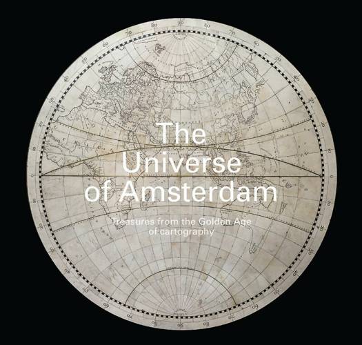
The Universe of Amsterdam
Treasures from the Golden Age of Cartography
Robbert Dijkgraaf, André Kuipers, Reinder Storm
Hardcover | Engels
€ 19,95
+ 39 punten
Omschrijving
The largest maps in the world are to be found in the floor of the Citizens' Hall, in the heart of the Royal Palace Amsterdam. The three circular mosaics, each measuring over six meters in diameter, together depict the known world and the night sky. They remain to this day an iconic and beloved part of the majestic palace, which was originally built in the mid-17th century to serve as Amsterdam's town hall. At that time, the city was the world's leading cartography centre. The prominent place of the floor maps relates directly to that primacy. This book tells the story of these unique maps and of the flourishing of cartography in Amsterdam in the 17th and 18th centuries.
Specificaties
Betrokkenen
- Auteur(s):
- Uitgeverij:
Inhoud
- Aantal bladzijden:
- 96
- Taal:
- Engels
- Geïllustreerd:
- Ja
Eigenschappen
- Productcode (EAN):
- 9789462622494
- Verschijningsdatum:
- 14/10/2020
- Uitvoering:
- Hardcover
- Formaat:
- Genaaid
- Afmetingen:
- 216 mm x 213 mm
- Gewicht:
- 566 g


Alleen bij Standaard Boekhandel
+ 39 punten op je klantenkaart van Standaard Boekhandel
E-BOOK ACTIE


Beoordelingen
We publiceren alleen reviews die voldoen aan de voorwaarden voor reviews. Bekijk onze voorwaarden voor reviews.