
- Afhalen na 1 uur in een winkel met voorraad
- Gratis thuislevering in België vanaf € 30
- Ruim aanbod met 7 miljoen producten
- Afhalen na 1 uur in een winkel met voorraad
- Gratis thuislevering in België vanaf € 30
- Ruim aanbod met 7 miljoen producten


Omschrijving
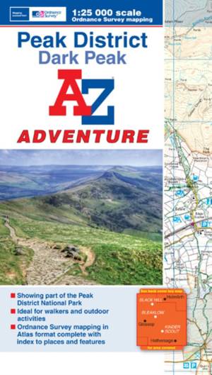
The A-Z Adventure series features the accuracy and quality of OS Explorer mapping in a convenient book, complete with index.The A-Z Adventure series is an innovative concept that utilises Ordnance Survey Explorer mapping in a book, therefore eliminating the need to fold and re-fold a large sheet map to the desired area. OS Explorer is Ordnance Survey's most detailed mapping at a scale of 1:25 000, showing public rights of way, open access land, national parks, tourist Information, car parks, public houses and camping and caravan sites.Unlike the original OS sheets, this A-Z Adventure Atlas includes a comprehensive index to towns, villages, hamlets and locations, natural features, nature reserves, car parks and youth hostels, making it easy to find the required location quickly. Each index entry has a page reference and a six figure National Grid Reference. At a book size of 240mm x 134mm it is the same size as a standard OS Explorer map when closed.This A-Z Adventure Atlas of the Peak District Dark Peak features 50 pages of continuous Ordnance Survey mapping covering: -Peak District National Park (northern part)-Kinder Scout-Hope Valley-Hathersage-Castleton-Snake Pass-Derwent ValleyThis A-Z Adventure Atlas has the accuracy and quality of OS Explorer mapping indexed within a book, making it the perfect companion for walkers, off-road cyclists, horse riders and anyone wishing to explore the great outdoors.Also available: A-Z Adventure Atlas of the Peak District, White Peak.
Specificaties
Betrokkenen
- Auteur(s):
- Uitgeverij:
Inhoud
- Aantal bladzijden:
- 60
- Taal:
- Engels
- Reeks:
Eigenschappen
- Productcode (EAN):
- 9781843488712
- Verschijningsdatum:
- 20/01/2015
- Uitvoering:
- Paperback
- Formaat:
- Trade paperback (VS)
- Afmetingen:
- 134 mm x 240 mm
- Gewicht:
- 112 g


Alleen bij Standaard Boekhandel
+ 26 punten op je klantenkaart van Standaard Boekhandel
AANGERADEN


Beoordelingen
We publiceren alleen reviews die voldoen aan de voorwaarden voor reviews. Bekijk onze voorwaarden voor reviews.