
Je cadeautjes zeker op tijd in huis hebben voor de feestdagen? Kom langs in onze winkels en vind het perfecte geschenk!
- Afhalen na 1 uur in een winkel met voorraad
- Gratis thuislevering in België vanaf € 30
- Ruim aanbod met 7 miljoen producten
Je cadeautjes zeker op tijd in huis hebben voor de feestdagen? Kom langs in onze winkels en vind het perfecte geschenk!
- Afhalen na 1 uur in een winkel met voorraad
- Gratis thuislevering in België vanaf € 30
- Ruim aanbod met 7 miljoen producten


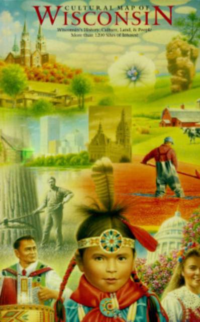
Cultural Map of Wisconsin
A Cartographic Portrait of the State
Gevouwen kaart | Engels
€ 19,95
+ 39 punten
Omschrijving
This extraordinary map, the first of its kind created for any state, is a wonderful way to discover the history, culture, land, and people of Wisconsin. Nearly 1500 points of interest are located on the map, including the sites of Laura Ingalls Wilder's Little House in the Big Woods near Pepin, the World's Largest Fish Fry at Port Washington, John Muir's boyhood farm near Montello, the Honor the Earth Pow Wow at Lac Court Oreilles, the nation's first kindergarten in Watertown, Hoard's Dairy Shrine in Fort Atkinson, the Pabst Mansion in Milwaukee, the great Peshtigo Fire, the Green Bay Packer Hall of Fame, and hundreds of other fascinating places.
The front of the map shows the entire state--topography, roads, waterways, historic sites and historical markers, archaeological areas, physical features and landscapes of cultural significance, notable architecture, areas of ethnic and religious importance, historic communities, festivals and fairs, lighthouses, museums and tours, colleges, parks and recreational trails, rustic roads, and places with celebrated literary, musical, and artistic connections. The back shows many more sites of interest on smaller cultural maps of sixteen cities. All the maps incorporate a shaded relief background that displays Wisconsin's rich variation in land forms, making it possible to see how local cultures are inextricably linked to regional landscapes. Six small thematic maps emphasize this linkage and show historical changes in vegetation, population patterns, and local economies.
Inset Maps for 16 Cities
Appleton, Eau Claire, Fond du Lac, Green Bay, Janesville/Beloit, Kenosha/Racine, La Crosse, Madison, Manitowoc, Milwaukee county including Waukesha, downtown Milwaukee, Oshkosh, Sheboygan, Stevens Point, Superior, Wausau
6 Theme Maps
Native American Cultures from Pre-contact to the Present, Patterns of Euro-American Settlement, Regions of Euro-American Culture, Economic Regions, Physical Geography and Glacial Processes, Vegetation in the 19th Century & late 20th Century
Site Key
Included with the map is a 16-page booklet with a key to the numbered symbols on the map.
Specificaties
Betrokkenen
- Auteur(s):
- Uitgeverij:
Inhoud
- Taal:
- Engels
Eigenschappen
- Productcode (EAN):
- 9780299152444
- Verschijningsdatum:
- 15/11/1996
- Uitvoering:
- Gevouwen kaart
- Afmetingen:
- 176 mm x 252 mm
- Gewicht:
- 181 g


Alleen bij Standaard Boekhandel
+ 39 punten op je klantenkaart van Standaard Boekhandel
CADEAU


Beoordelingen
We publiceren alleen reviews die voldoen aan de voorwaarden voor reviews. Bekijk onze voorwaarden voor reviews.