
- Afhalen na 1 uur in een winkel met voorraad
- Gratis thuislevering in België vanaf € 30
- Ruim aanbod met 7 miljoen producten
- Afhalen na 1 uur in een winkel met voorraad
- Gratis thuislevering in België vanaf € 30
- Ruim aanbod met 7 miljoen producten


Omschrijving
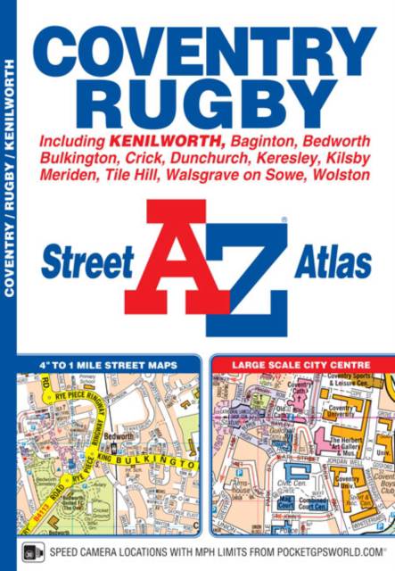
This A-Z map of Coventry and Rugby features 45 pages of continuous street mapping extending to: -Bedworth-Bulkington-Keresley-Allesley-Baginton-Coventry Airport-Kenilworth-Wolston-Long Lawford-Clifton upon Dunsmore-Kilsby-Crick-DunchurchAlso included are inset maps of Meriden, Brownsover and Thurlaston and a large scale city centre map of Coventry.Postcode districts, one-way streets and safety camera locations with speed limits are also featured on the mapping.The index section lists streets; selected flats, walkways and places of interest; place, area and station names; hospitals and hospices covered by this atlas.
Specificaties
Betrokkenen
- Auteur(s):
- Uitgeverij:
Inhoud
- Aantal bladzijden:
- 68
- Taal:
- Engels
Eigenschappen
- Productcode (EAN):
- 9781782571155
- Verschijningsdatum:
- 29/03/2016
- Uitvoering:
- Paperback
- Formaat:
- Trade paperback (VS)
- Afmetingen:
- 149 mm x 215 mm
- Gewicht:
- 120 g


Alleen bij Standaard Boekhandel
+ 20 punten op je klantenkaart van Standaard Boekhandel
E-BOOK ACTIE


Beoordelingen
We publiceren alleen reviews die voldoen aan de voorwaarden voor reviews. Bekijk onze voorwaarden voor reviews.