
- Afhalen na 1 uur in een winkel met voorraad
- Gratis thuislevering in België vanaf € 30
- Ruim aanbod met 7 miljoen producten
- Afhalen na 1 uur in een winkel met voorraad
- Gratis thuislevering in België vanaf € 30
- Ruim aanbod met 7 miljoen producten


€ 8,45
+ 16 punten
Omschrijving
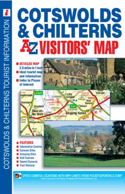
This map of the Cotswolds & Chilterns is a full colour visitors' map featuring road mapping that covers an area extending to: -Worcester-Royal Leamington Spa-Northampton-Bedford-Dunstable-London Heathrow Airport-Reading-Newbury-Marlborough-Bath-Bristol-Ross-on-WyeThis Cotswolds & Chilterns Visitors' Map is shown at a clear 2.5 miles to 1 inch scale (1.6 kms to 1 cm) and includes the following features: -Motorways open with full junction detail, motorways under construction and proposed, service areas, primary routes and destinations, A & B roads, gradients 1:5 and steeper, tolls, mileages and national and county boundaries.-Selected safety camera locations with their maximum speed limits and fuel stations.-Selected places of interest, tourist information centres, caravan and camping sites and golf courses.The index is printed adjacent to the mapping and lists cities, towns, villages, hamlets, locations and selected places of interest shown on the map.
Specificaties
Betrokkenen
- Auteur(s):
- Uitgeverij:
Inhoud
- Aantal bladzijden:
- 1
- Taal:
- Engels
Eigenschappen
- Productcode (EAN):
- 9781782570332
- Verschijningsdatum:
- 4/04/2014
- Uitvoering:
- Paperback
- Formaat:
- Trade paperback (VS)
- Afmetingen:
- 154 mm x 239 mm
- Gewicht:
- 136 g


Alleen bij Standaard Boekhandel
+ 16 punten op je klantenkaart van Standaard Boekhandel
E-BOOK ACTIE


Beoordelingen
We publiceren alleen reviews die voldoen aan de voorwaarden voor reviews. Bekijk onze voorwaarden voor reviews.