
- Afhalen na 1 uur in een winkel met voorraad
- Gratis thuislevering in België vanaf € 30
- Ruim aanbod met 7 miljoen producten
- Afhalen na 1 uur in een winkel met voorraad
- Gratis thuislevering in België vanaf € 30
- Ruim aanbod met 7 miljoen producten


Omschrijving
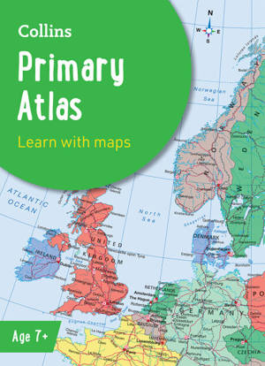
Discover the world with this engaging, educational atlas from CollinsCollins Primary Atlas is a great introduction to mapping of the UK, Europe and all major regions of the world. It supports the Key Stage 2 curriculum and is suitable for children aged 7-11 years.This new, fully up-to-date edition includes information on map reading skills, the meaning of scale and measuring distances, and is ideal for classroom use or home learning.Reference maps:• Informative, politically coloured and easy-to-read• National capitals and major cities are clearly labelled• Maps are supported with national flags and basic national statisticsContinental maps:• Linked to regional mapping• Supported by a selection of aerial and terrestrial photographs• Relief maps show layer colouring and highlight major physical featuresThis atlas is also available in a Kindle format. The next atlas in the series is the Collins School Atlas, suitable for ages 11+ and KS3.
Specificaties
Betrokkenen
- Uitgeverij:
Inhoud
- Aantal bladzijden:
- 68
- Taal:
- Engels
- Reeks:
Eigenschappen
- Productcode (EAN):
- 9780008762025
- Verschijningsdatum:
- 12/02/2025
- Uitvoering:
- E-book
- Beveiligd met:
- Adobe DRM
- Formaat:

Alleen bij Standaard Boekhandel
+ 8 punten op je klantenkaart van Standaard Boekhandel
E-BOOK ACTIE


Beoordelingen
We publiceren alleen reviews die voldoen aan de voorwaarden voor reviews. Bekijk onze voorwaarden voor reviews.