
- Afhalen na 1 uur in een winkel met voorraad
- Gratis thuislevering in België vanaf € 30
- Ruim aanbod met 7 miljoen producten
- Afhalen na 1 uur in een winkel met voorraad
- Gratis thuislevering in België vanaf € 30
- Ruim aanbod met 7 miljoen producten


€ 12,95
+ 25 punten
Omschrijving
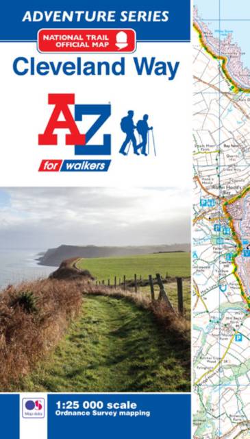
The A-Z Adventure Series of maps combines the best of OS and A-Z, creating the perfect companion for walkers, off-road cyclists, horse riders and anyone wishing to explore the great outdoors.The Cleveland Way is a 109 mile (175 km) National Trail from Helmsley in the North York Moors National Park, to Saltburn-by-the-Sea, where it joins and then follows the coast to finish in Filey. The trail combines beautiful heather moorland countryside offering panoramic views and a dramatic coastline with spectacular coastal scenery. There are numerous historical buildings, ancient features, interesting towns and fishing villages to encounter along the way. The route on the map is clearly highlighted in yellow.This official National Trail Map* of the Cleveland Way features 39 pages of continuous Ordnance Survey 1:25000 mapping providing complete coverage of the Cleveland Way. The atlas includes a route planner showing distances between places and the amenities available, featuring: -Information Centres-Hotels/B&Bs-Youth Hostels-Campsites (seasonal opening)-Public Houses-Shops-Restaurants-Cafes (seasonal opening)-Petrol StationsAlso featured is advice on safety and security when walking and a selection of QR codes linked to useful websites, including temporary route updates from the National Trails, regional information, map reading advice and weather reports.Unlike the original OS sheets, this A-Z Adventure Atlas includes a comprehensive index to towns, villages, hamlets and locations, natural features, nature reserves, car parks and youth hostels, making it easy to find the required location quickly. Each index entry has a page reference and a six figure National Grid Reference. With a book size of 240mm x 134mm it is the same size as the standard OS folded map.Other National Trails available within the A-Z Adventure series include: Cotswold Way, England Coast Path (sections), Hadrian's Wall Path, Norfolk Coast Path & Peddars Way, North Downs Way, Pembrokeshire Coast Path, Offa's Dyke Path, Pennine Way, South Downs Way, SW Coast Path, Thames Path, The Ridgeway and Yorkshire Wolds Way.*A-Z is the official mapping partner of the National Trails.
Specificaties
Betrokkenen
- Auteur(s):
- Uitgeverij:
Inhoud
- Aantal bladzijden:
- 52
- Taal:
- Engels
- Reeks:
Eigenschappen
- Productcode (EAN):
- 9781782571964
- Verschijningsdatum:
- 15/08/2017
- Uitvoering:
- Paperback
- Formaat:
- Trade paperback (VS)
- Afmetingen:
- 134 mm x 240 mm
- Gewicht:
- 100 g


Alleen bij Standaard Boekhandel
+ 25 punten op je klantenkaart van Standaard Boekhandel
E-BOOK ACTIE


Beoordelingen
We publiceren alleen reviews die voldoen aan de voorwaarden voor reviews. Bekijk onze voorwaarden voor reviews.