- Afhalen na 1 uur in een winkel met voorraad
- Gratis thuislevering in België vanaf € 30
- Ruim aanbod met 7 miljoen producten
- Afhalen na 1 uur in een winkel met voorraad
- Gratis thuislevering in België vanaf € 30
- Ruim aanbod met 7 miljoen producten
Zoeken
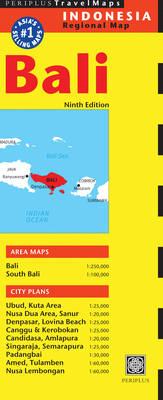
Bali Travel Map
Gevouwen kaart | Engels
€ 14,45
+ 28 punten
Omschrijving
The Bali Travel Map from Periplus is designed as a convenient, easy-to-use tool for travelers. Created using durable coated paper, this map of China is made to open and fold multiple times, whether it's the entire map that you want to view or one panel at a time. Following highways and byways, this map will show you how to maneuver your way to banks, gardens, hotels, golf courses, museums, monuments, restaurants, churches and temples, movie theaters, shopping centers and more! This 9th edition area maps and city plans are scaled to:
A unique, easy-to-handle folding system that allows you to view the map one panel at a time for quick reference, and a fully digital map base, which allows our maps to be frequently updated. Periplus Travel Maps cover most of the major cities and travel destinations in the Asia-Pacific region. The series includes an amazing variety of fascinating destinations, from the multifaceted subcontinent of India to the bustling city-state of Singapore and the 'western style' metropolis of Sydney to the Asian charms of Bali. All titles are continuously updated, ensuring they keep up with the considerable changes in this fast-developing part of the world. This extensive geographical reach and attention to detail mean that Periplus Travel Maps are the natural first choice for anyone traveling in the region.
- Bali at 1:250,000
- South Bali at 1:100,000
- Amed at 1:60,000
- Tulamben at 1:60,000
- Nusa Dua Area at 1:20,000
- Nusa Lembongan at 1:60,000
- Lovina Beach at 1:25,000
- Ubud at 1:25,000
- Amlapura at 1:20,000
- Padangbai at 1:30,000
- Candidasa at 1:20,000
- Canggu & Kerobokan at 1:25,000
- Kata Area at 1:25,000
- Semarapura at 1:25000
- Singaraja at 1:25,000
- Sanur at 1:20,000
- Denpasar at 1:25,000
A unique, easy-to-handle folding system that allows you to view the map one panel at a time for quick reference, and a fully digital map base, which allows our maps to be frequently updated. Periplus Travel Maps cover most of the major cities and travel destinations in the Asia-Pacific region. The series includes an amazing variety of fascinating destinations, from the multifaceted subcontinent of India to the bustling city-state of Singapore and the 'western style' metropolis of Sydney to the Asian charms of Bali. All titles are continuously updated, ensuring they keep up with the considerable changes in this fast-developing part of the world. This extensive geographical reach and attention to detail mean that Periplus Travel Maps are the natural first choice for anyone traveling in the region.
Specificaties
Betrokkenen
- Auteur(s):
- Uitgeverij:
Inhoud
- Taal:
- Engels
Eigenschappen
- Productcode (EAN):
- 9780794607395
- Verschijningsdatum:
- 6/05/2014
- Uitvoering:
- Gevouwen kaart
- Afmetingen:
- 259 mm x 99 mm
- Gewicht:
- 68 g

Alleen bij Standaard Boekhandel
+ 28 punten op je klantenkaart van Standaard Boekhandel
Beoordelingen
We publiceren alleen reviews die voldoen aan de voorwaarden voor reviews. Bekijk onze voorwaarden voor reviews.


