- Afhalen na 1 uur in een winkel met voorraad
- Gratis thuislevering in België vanaf € 30
- Ruim aanbod met 7 miljoen producten
- Afhalen na 1 uur in een winkel met voorraad
- Gratis thuislevering in België vanaf € 30
- Ruim aanbod met 7 miljoen producten
Zoeken
Omschrijving
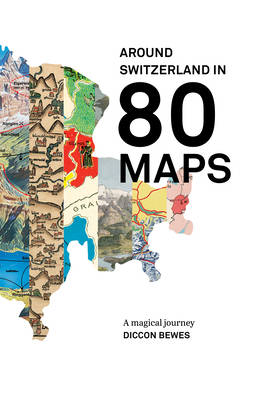
A tour of Switzerland through historical and contemporary maps
A map is the perfect pictorial way to explain and entertain. This book achieves both of these goals and provide a detailed picture of Switzerland. Diccon Bewes’ search for original maps led him through official archives and private collections. The results are presented here, along with the fascinating stories behind them: from the circular island map of 1480 to the birth of modern Swiss cartography; from the British rail plan for Switzerland to a Soviet map of Basel during the Cold-War; from the 1970s Zurich map for men to the vision of a Greater Switzerland with 40 cantons.
A map is the perfect pictorial way to explain and entertain. This book achieves both of these goals and provide a detailed picture of Switzerland. Diccon Bewes’ search for original maps led him through official archives and private collections. The results are presented here, along with the fascinating stories behind them: from the circular island map of 1480 to the birth of modern Swiss cartography; from the British rail plan for Switzerland to a Soviet map of Basel during the Cold-War; from the 1970s Zurich map for men to the vision of a Greater Switzerland with 40 cantons.
Specificaties
Betrokkenen
- Auteur(s):
- Uitgeverij:
Inhoud
- Aantal bladzijden:
- 226
- Taal:
- Frans
Eigenschappen
- Productcode (EAN):
- 9782940481309
- Uitvoering:
- Boek
- Afmetingen:
- 233 mm x 331 mm
- Gewicht:
- 1367 g

Alleen bij Standaard Boekhandel
+ 66 punten op je klantenkaart van Standaard Boekhandel
Beoordelingen
We publiceren alleen reviews die voldoen aan de voorwaarden voor reviews. Bekijk onze voorwaarden voor reviews.


