
- Afhalen na 1 uur in een winkel met voorraad
- Gratis thuislevering in België vanaf € 30
- Ruim aanbod met 7 miljoen producten
- Afhalen na 1 uur in een winkel met voorraad
- Gratis thuislevering in België vanaf € 30
- Ruim aanbod met 7 miljoen producten


€ 8,45
+ 16 punten
Omschrijving
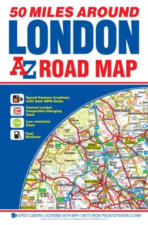
This A-Z 50 Miles around London map is a full colour, single sided road map featuring continuous mapping extending from Rugby and Bury St. Edmunds to the south coast and from Oxford and Winchester to Margate and Felixstowe in the east.Published at a clear 3.5 miles to 1 inch the following features are shown on the road mapping: -Motorways open with full junction detail, motorways under construction and proposed, service areas, primary routes and destinations, A & B roads, selected minor roads, gradients 1:5 and steeper, tolls, mileages, county boundaries, spot heights and hill shading-Selected safety camera locations with maximum speed limits-Selected fuel stations-A wide range of ancillary and tourist information-South Downs National Park boundaryAn index to cities, towns, villages, hamlets and locations is adjacent to the map.
Specificaties
Betrokkenen
- Auteur(s):
- Uitgeverij:
Inhoud
- Taal:
- Engels
Eigenschappen
- Productcode (EAN):
- 9781782571087
- Verschijningsdatum:
- 25/11/2015
- Uitvoering:
- Paperback
- Formaat:
- Trade paperback (VS)
- Afmetingen:
- 152 mm x 241 mm


Alleen bij Standaard Boekhandel
+ 16 punten op je klantenkaart van Standaard Boekhandel
E-BOOK ACTIE


Beoordelingen
We publiceren alleen reviews die voldoen aan de voorwaarden voor reviews. Bekijk onze voorwaarden voor reviews.